If your Mexico Beach home has a great location, a wide lot, water access, or standout outdoor space, regular listing photos may only tell part of the story. Buyers today do a lot of their home search online, and according to the National Association of Realtors 2025 generational trends report, photos are the most useful website feature for buyers who use the internet. That is why drone photography can be such a powerful tool for coastal listings. It helps you show not just the house, but the setting that makes Mexico Beach so appealing. Let’s dive in.
Why visuals matter more than ever
When buyers first see your listing, they are usually deciding within seconds whether to keep looking. Strong visuals help them understand the home faster and picture how it fits their goals, whether they are searching for a primary residence, a second home, or a vacation property.
The data backs that up. In addition to photos ranking highest in buyer usefulness, NAR’s 2025 Profile of Home Staging found that 73% of buyers’ agents rated photos as much or more important for listings, while 48% said the same about videos and 43% about virtual tours. For sellers, this means your marketing package matters just as much as your pricing strategy.
Why drone photography fits Mexico Beach
Mexico Beach has features that are hard to capture from the ground. The city highlights its 3.1 miles of white sand beaches, canal system, boat ramp, parks, and Gulf access, all of which shape how buyers experience a property. If your listing is near the shoreline, close to a canal, or positioned near local access points, aerial media can make those connections clear right away.
The city also promotes public parks, walking trails, courts, and local shopping and dining options. Those location details often influence how buyers compare homes, especially when they are unfamiliar with the area. Aerial images can show context in one frame that might otherwise take a long gallery of photos to explain.
In a coastal market, place is part of the value. Mexico Beach also notes its bird sanctuary status and emphasizes turtle protection and dune preservation on its visitor pages, which means the natural setting is an important part of the story a listing should tell in a respectful, responsible way.
What drone photos can show better
According to NAR’s guidance on drone use in real estate marketing, aerial media is especially effective for highlighting landscape, outdoor features, location, surrounding area, and views. In Mexico Beach, that can make a real difference.
Here are some of the details drone photography can help buyers understand more quickly:
- A home’s relationship to the beach or canal
- Lot size and lot shape
- Rooflines and overall property layout
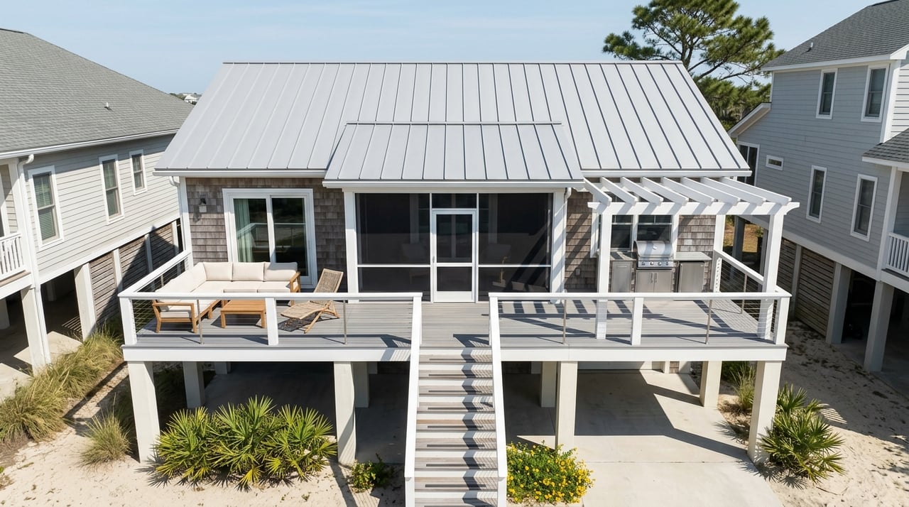
- Decks, porches, patios, and pools
- Parking and access points
- Nearby parks, water access, and surrounding streets
- The broader coastal setting and nearby open space
That kind of visual clarity helps buyers see the full package. For properties with elevated architecture, outdoor living areas, or water-oriented features, those details often become much easier to appreciate from above.
Aerial media helps out-of-town buyers
Many coastal buyers are not local, and some are shopping for second homes or vacation properties. NAR notes that drone imagery is especially useful for buyers moving from another city, buying a second home, or trying to streamline research before visiting in person.
That matters in Mexico Beach, where some interested buyers may not be able to tour right away. Aerial photos and video can help them understand the home’s setting before they make travel plans, which can lead to more serious interest and more informed showings.
The best results come from a full media package
Drone photography works best when it is part of a larger strategy. The same NAR buyer trends report that ranked photos highly also found that buyers value floor plans, virtual tours, and videos. In other words, buyers want a complete picture.
For a Mexico Beach listing, the strongest presentation usually includes:
- Professional interior and exterior photography
- Drone photography and aerial video
- Floor plans
- Virtual tour options when appropriate
- Thoughtful listing preparation, including staging or improvement guidance when needed
This kind of package helps your home feel polished, clear, and easy to understand online. It also supports the goals sellers care about most. NAR’s 2025 home buyer and seller highlights found that sellers place top priority on marketing the home, pricing it competitively, and selling within a specific timeframe.
What a strong Mexico Beach drone shoot includes
Not every aerial shoot creates the same impact. The most effective drone content does more than capture a few high shots. It tells a story about how the home sits in its environment.
For many Mexico Beach listings, that story works best in this order:
- Neighborhood context so buyers can understand the setting
- The property itself to show scale, layout, and design
- Outdoor living spaces like porches, decks, patios, or pools
- Nearby beach or water access to show how the location supports coastal living
This approach helps buyers connect the dots. Instead of asking, “How close is it?” or “What does the lot really look like?” they can often see the answer for themselves.
Professional execution matters
Drone photography can add a premium feel to your listing, but only when it is handled correctly. The FAA’s drone rules overview explains that commercial drone use requires compliance with Part 107 rules, including a remote pilot certificate and drone registration for business use. The FAA also says pilots generally must keep flights below 400 feet, maintain visual line of sight, and follow Remote ID requirements.
NAR also recommends checking a drone vendor’s certificate, insurance coverage, copyright terms, and indemnity language before hiring. That is an important step for any seller who wants polished media without unnecessary risk.
Local awareness matters too. Mexico Beach’s beach rules prohibit disturbing dunes and vegetation, and the city highlights environmental protections tied to its shoreline. In a place like Mexico Beach, great marketing should also respect the local coastal environment.
Drone photography supports premium positioning
Some sellers still think of drone photography as an extra. In reality, it is better understood as part of a modern marketing plan, especially in a coastal market where location and setting drive interest.
NAR’s 2025 technology survey found that 75% of REALTORS used drone photography or video, and 45% said clients responded very positively to technology during the buying and selling process. That tells you two things. First, buyers and sellers already expect a professional digital experience. Second, strong visual marketing helps your listing compete.
When your home is marketed with clear strategy, strong imagery, and local insight, buyers can understand its value faster. That is especially important in Mexico Beach, where proximity to the beach, outdoor living, and water access can shape how a property is perceived.
Why this matters for your sale
If you are selling in Mexico Beach, you are not just marketing square footage. You are marketing the setting, the lifestyle, and the features that make the property stand out in a coastal market. Drone photography helps communicate those details in a way buyers can actually absorb online.
With deep Forgotten Coast knowledge, hands-on listing preparation, and professional marketing that includes drone imagery and virtual tours, Chasity Hill helps sellers present their properties at a higher level. If you want a smart plan for showcasing your Mexico Beach listing, Talk with Chasity and schedule a tour.
FAQs
How does drone photography help sell a Mexico Beach home?
- Drone photography helps buyers see the property’s location, lot layout, outdoor spaces, and relationship to the beach, canal, parks, or access points in a way ground-level photos often cannot.
Is drone photography worth it for smaller Mexico Beach listings?
- Yes. Even smaller properties can benefit if aerial images help show beach proximity, lot context, parking, outdoor features, or nearby water access.
What should drone photos show for a Mexico Beach property?
- The most effective drone photos usually show neighborhood context, the home’s footprint, roofline, decks or patios, parking areas, and nearby beach or water-related features.
Can drone media help out-of-town buyers shopping in Mexico Beach?
- Yes. NAR notes that drone imagery is especially useful for buyers moving from another city, buying a second home, or trying to narrow choices before an in-person visit.
Are there rules for drone photography in Mexico Beach?
- Yes. Commercial drone use must follow FAA rules, and responsible shoots should also respect local beach rules, including protections for dunes, vegetation, and the surrounding coastal environment.
Should drone photography be used by itself in a Mexico Beach listing?
- No. It works best when paired with professional interior photos, floor plans, and virtual tours so buyers get a more complete understanding of the property.